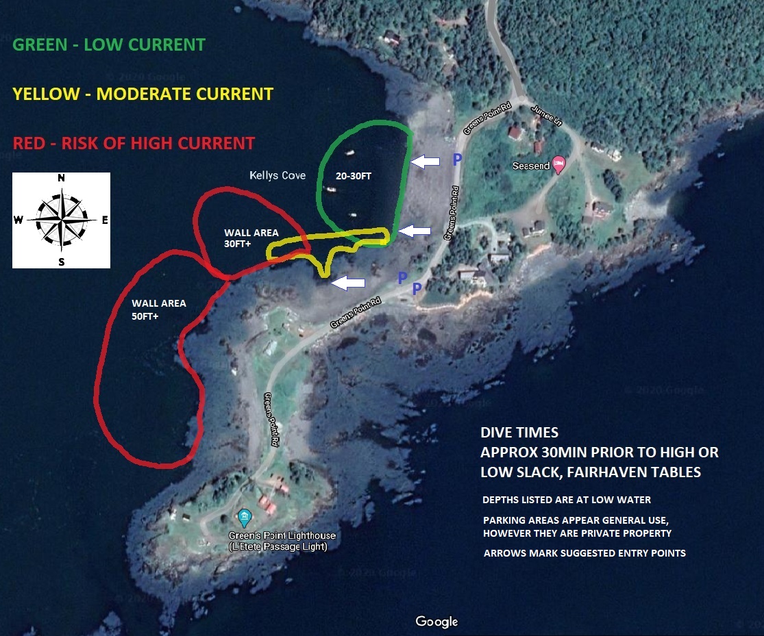
This is a more advanced dive site with several options, and can be a very nice dive with a wide variety of marine life.
The site has a Westerly exposure, care should be taken if strong wind is forecasted out of the NW, West, or SW.
The site is tide dependent, and is best at low slack tide. We suggest starting the dive approx 30min prior to the forecasted slack using Fairhaven tables.

DIRECTIONS
From Route 1 in New Brunswick, take the exit for St. George and Deer Island. Follow the signage to the Deer Island ferry, turn left on to Green Island Point Road prior to the ferry road.
SITE
Entry to the site is made at Kelly's Cove, several points of entry are possible (see image above).
The roadway is narrow and doesn't have much room to pull off except at the most northerly parking area noted. The lower parking areas have room to park a few vehicles off the road, however please note these are extensions of private property with tolerance for common use. Please respect the area when you visit.
The image above gives an idea of the complexity of the site. The "Green" area has been observed to have the least amount of current and is mainly a flat bottom. The "Yellow" area starts into a rocky bottom with a nice wall, that is only around 30ft deep or so (at low slack). One can experience a moderate current in the Yellow area, which can be strong close to shore as the tide starts to turn. The "Red" areas are interesting as the rocky reefs and walls provide an entertaining area to explore with a wide variety of marine life, but the current can become quite strong.
ENTRY
Access the water from the rocky beach in the areas noted in the above image. Entry is easiest at high slack tide, however entry at low slack tide is easy as well.
VISIBILITY
Ranges from 10-20'
WATER TEMP
32F (Feb-Mar) to 55F (Aug-Sep)
HAZARDS
Safety gear including a SMB, whistle and light are strongly recommended.
Currents are a major factor at this site, divers should stay close to the bottom in case there is a need to "pull".
If a diver has to surface, the surface current can be quite different than conditions below. If a diver has to surface and find the current is too strong to reach the entry point, deploy a surface marker and swim at an angle across the current to reach shore. It would be ideal (if conditions and air supply permit), to take a bearing to shore and descend as it is typically easier to follow the bottom back to shore.
Storm conditions with a strong NW/West/SW can lower the visibility considerably, also extreme tidal ranges (i.e. Full & New Moon dates, "Spring Tides")
BOTTOM
Varied- soft & rocky within the main cove, rocky ridges and walls in the areas south of the main cove.
FEATURES
The rocky areas are home to a wide variety of marine life including crabs, lobster, sea raven, sculpin, anemones, tunicates, nudibranch, brittle star, star fish, slime worms, sponges.
REFERENCES
We recommend a visit to the Green's Point Lighthouse and Museum while in the area. It's a beautiful area to explore around the lighthouse as well!
